Valley County Pathways has worked with Valley County Parks & Recreation and the Valley County Transportation Department to update its recommended short-term and long-term pathways projects. The master plan update reflects our latest priorities for trail development as things have evolved since 2017, when the last VCP Master Plan was approved by the Valley County Commissioners.
Highest priority projects for VCP:
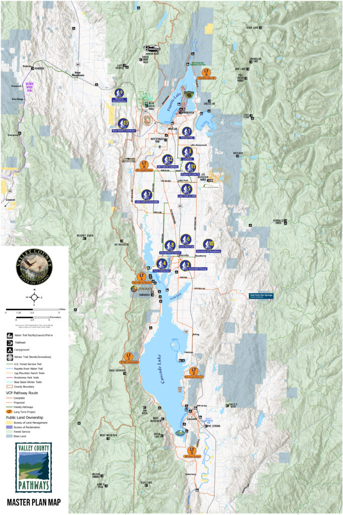
- Donnelly Flyway – Developing a new walking/biking pathway from downtown Donnelly to the city beach on Lake Cascade via a trail next to the Donnelly Airport (grass airstrip). Distance is 1.3 miles. The City of Donnelly has given VCP a local option grant to assist with project construction. Timeline: Summer 2021.
- Samson Trail Safe Route to Schools – a 2.5-mile trail from the Payette Middle School to Pearson Lane.
- Connect Samson Trail to Rogers Lane via Carefree subdivision. This is a 3-mile trail project that was broadly supported by McCall-area residents.
- Tamarack Falls to Tamarack Resort – Developing a paved or natural surface trail that flows through the campgrounds and picnic areas along Lake Cascade waterfront. This project is a high priority for Tamarack Resort, campers and recreationists in that corridor.
- Lake Fork to Donnelly – This 10-mile section was listed as a high-priority in our online surveys and public meetings. The actual route selected from Lake Fork to Donnelly will be determined via public outreach meetings with local community, ranchers and landowners. Long-range plans call for building a singletrack sidewalk along Norwood or Nisula or a combination thereof to provide a pathway corridor between those two communities in the mid-valley. Timing: TBD.
- West Mountain Greenbelt – This section of pathway would run south of Tamarack Resort to French Creek Campground or farther south as a long-range scenic pathway running alongside Bureau of Reclamation and Forest Service land on the west side of Lake Cascade. Timing: TBD.
- Create a pedestrian pathway corridor on the East side of Payette Lake.