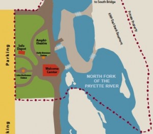
Open Kelly’s Whitewater Park Area Map
The map shows the connection between Kelly’s Whitewater Park (KWP) and The Strand, a 2.5 mile walking/bicycling path, a Valley County Pathways project, along the North Fork of the Payette River. You can access The Strand by Fischer Pond Park next to the south Hwy 55 bridge in Cascade, and the pathway runs north to the RV parks at the north end of town. The KWP beau
Kelly’s Whitewater Park is rapidly growing an excellent reputation. The National Kayak Freestyle Championships were held at the park in early July, with more than 5,000 spectators and many of the nation’s best freestyle kayakers. The whitewater park is available for all paddlers, kayakers, tubers and rafters. And it’s all free. Kelly’s Kayak School operates in the summer, check it out at kwpid.com.
Come visit and check out the statues of Kelly Brennan, for whom the park is named, and John Borbonus, an American soldier killed in Iraq.
KWP is accessed via Hwy 55, next to the RR Crossing in Cascade. We hope to see you soon! (See Google Map below.)
– Dwight Jividen, Valley County Pathways board member in Cascade

Comments are closed